Sunday, July 27, 2008

Tara Cove


Tara Cove, Uploaded by M+MD.

Tara Cove
Uploaded by M+MD

We had a lovely week in Tara Cove. I was commuting each day while Senan Mags and Peg were down for the whole week. The weather was good but not outstanding - until this week-end when we had to go home - it really picked up. Barney and Mairead and their crew are taking it for two weeks and they certainly have had a great start - weatherwise. In the evening there were some lovely sunsets - and early one morning as I headed of to Dublin there was this fantastic Rainbow. As usual it is hard to capture it in a picture - but I'm pretty pleased with these results.


Tara Cove, Uploaded by M+MD.

Sunday, July 20, 2008

Epilogue Thursday 20 July 1978

After breakfast we walked into Ambleside and caught a bus to Keswick at 10.00 or so, getting into Keswick at 11.00. We walked down to the Manor and got breakfast again! Martin and Barney too what gear we needed and left various saucepans etc which we didn’t need. We then saw Paul and Sheila installed in Castlerigg. We said goodbye to them all there and with a good packed lunch from John, Barney and Martin walked out to the Penrith road to hitch to Scotland After a long wait we eventually got a lift ….ah but therein lies another story.

Saturday, July 19, 2008

Day XI - Wednesday 19 July 1978

Morning brought a dull day, but no sign of rain. We had breakfast with our usual speed and efficiency – life is so straight-forward in a hostel. Soon we were packed and had our chores done.

We set out at 9.15 – well armed with sweets and sandwiches. The sun made a token appearance. We walked about a mile back the road we had walked yesterday. Then we turned into Grisdale. There was a bit of a breeze, but it seemed like ideal conditions for walking. We had company on the way up – well for a bit of the way – two guys from the hostel – however they were in too much of a hurry and soon almost disappeared from sight.

As we climbed it threatened to rain a couple of times – but every time we put on our coats it stopped. Sometimes it would be drizzling down in the valley but we would be in the sunshine.

We made good progress, though we had an ambitious programme, we hoped to walk to Ambleside, a total of 14 miles and a lot of climbing, however we would be happy with Grasmere and a bus to Ambleside.

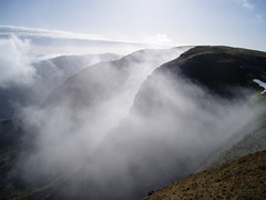
At 2,200 ft we reached the end of the first long climb. At this point the wind was quite fierce and the mist was blowing down from the summit. We thought of Striding Edge with just a little fear. After a rest and some chocolate and after preparing ourselves as best we could for the weather we set off. It was quite a struggle to walk into the wind and the rain on the wind burnt our faces. However, as we approached Striding Edge the wind eased up quite a bit. We couldn’t see very well, but soon we could see what we knew must be the beginning of the Edge.


Striding Edge IMG_4608.jpg
Originally uploaded by Rich_1

Helvellyn 036
Originally uploaded by Pat Neary
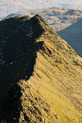
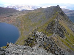
The rocks were quite slippery and the path a little uncertain. We discovered there were two paths across Striding Edge – one on the very top and one just underneath it. Given the weather conditions and our heavy packs we decided to take the low road. The going got quite slow, though it picked up as the path became clearer.

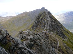
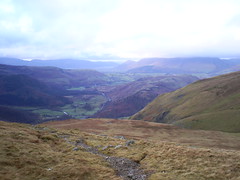
And so we walked along Striding Edge, in the mist, unable to see its full properties. On we went first on the right hand side of the edge, then on the left and then back to the right-hand side – occasionally the mist would blow away and we could see Red Tarn below us.


Helvellyn 047
Originally uploaded by Pat Neary

As we approached the end of Striding Edge, a rock chimney looked just a bit too like hard work for our liking and we veered off the path and down to its right. Our only path now was sheep tracks and small gullies of scree. However we continued to climb. Below us – almost immediately below, was red Tarn, a lonely looking sight in the mist – with the odd seagull flying above and screeching, making an eerie sort of half echo off the mountain wall – and it was a wall. Red Tarn is the perfect corrie lake with two arêtes – one on each side, stretching like arms on a throne.

The top came as a surprise – the best way. It was miserable and cold. We rested at te shelter, doing our very best to keep warm and not succeeding very well. We didn’t feel like eating anything there. The wind and rain were biting. A quick walk to the very top where we were nearly blown off! We actually lay back against the wind and it supported us standing up, it was that strong. We met a man and his sheepdog on top – the poor dog had nearly blown off Swirral Edge and the man was anxious about going down Striding Edge as he had originally planned.


misty ridges
Originally uploaded by torpenhow3
We almost ran from the top of Helvellyn and such was our hurry to get we took the short way i.e. down to Thirlmere rather than along the ridge to Dollywagon Pike.

We suddenly found ourselves out of the mist, almost down and it was only 1.30 we stopped and ate. It wasn’t warm, but it certainly wasn’t cold and there was no rain. We looked to the summit to see it shrouded in mist. We shuddered a little at the thought of the cold up there.

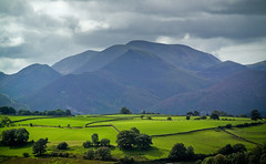
After a good rest we descended to the forest. Once in the forest we took a forest road running parallel to the main road. We continued on this road and then on a path until we were parallel with Dunmail Raise. We went down to the main road and examined the Raise (a cairn built to King Dunmail, whoever he was). Then we descended into Grasmere by road, getting a good look at the Lion and the Lamb and also the Piano Player!

As we reached the Swan Hotel (cheapest pint around) a bus pulled up. This was too big a temptation and so at 4.00 pm our walking ended as we stepped on board the bus which brought us the last few miles.

It was with just a little sadness that we felt ourselves brought along by a means other that our own two feet, for the first time in 240 hours! We had walked a total of 11½ miles that day and a total of 111¾ miles in all.

We walked to Ambleside youth hostel from the bus station , after having done some shopping in the town.We treated ourselves to a good farewell dinner – Vesta Chicken and rice – delicious and strawberries and cream. Mmmm.

We then walked into Ambleside and looked around, rang Keswick, bought chips and wandered back to the hostel and bed.

Friday, July 18, 2008

Day X - Tuesday 18 July 1978

We got up late – I suppose because we were in bed late! Martin went into Keswick and did all the shopping. Then we went into the Manor and John threw us up a fabulous breakfast. After that Martin asked Fr Foulkes if Sheila and Paul could stay a few days – they’re full up but he said he should be able to arrange something. We arranged to ring later today or tomorrow to find out.


Blencathra from Castlerigg, originally uploaded by BBurrows.

So it was late when we set off on what was to be our longest day – the Helvellyn range from Keswick – Great Dodd, Watsons Dodd, Stybarrow Dodd, Sticks Pass, Raise, Helvellyn and down Striding Edge to Patterdale – a total of about 14 or 15 miles.


Greener Pastures
Originally uploaded by tommy martin
We had a long walk first into St John’s in the Vale before we started to climb, but once we were up it was a ridge walk all the way with just a few ups and downs.

It was 12.00 before we started to climb. We decided to follow a path which seemed more gradual rather than the path that was steep. However this only lead us around the mountain and we really didn’t gain much height.

It was also dark and overcast and rain seemed certain. We eventually decided to leave this path and just climb.

As we got to the ridge the rain came. Then we saw the extent of our error – we had started one hill too far over and so we had put an extra walk on ourselves. Well it was Martin’s fault – overreliance on Wainwright and not using the map in conjunction with it. No, we won’t blame Wainwright we’ll just blame the person who misread it! So we started around the hill to get back onto the original route. In the meantime the tops were quite misty and wet looking.

A few songs helped pass the time and though everybody’s feet were wet (except Martin in his “spaceboots”) we were soon back on the original path. Although Great Dood looks quite fearsome from St John’s in the Vale its quite tame and grassy on top. We then continued over to Watson’s Dodd.

It was getting misty and late and the thought of Helvellyn and Striding edge was not very pleasant. We decided therefore to leave Helvellyn ‘til to-morrow – that would leave us going up striding edge and also the possibility of a clear day on top. So we decided to go down Sticks Pass and just have the 3 Dodds as our accomplishment for today. We continued on to Stybarrow Dodd and then down to Sticks Pass. It was now very misty.


Sticks Pass
Originally uploaded by andrewginty

Half way down Sticks Pass we had our lunch – a few bumper sandwiches! Plus some hoppity harrys in the lettuce! – protein! Then the rain started. A few more songs helped us down. We passed the remains of some old mines in Glenridding. The place looked pretty grim in the rain.

When we got down to the village there were a couple of shops. We did some shopping and then walked to the hostel, about 2 miles on the road. The hostel in Patterdale was beautiful. It’s a new building with very good facilities. There we met the couple we had met in Ennerdale; they were progressing on the Coast to Coast walk. As usual we prepared a big feed of spaghetti. Showers were enjoyed by all.

After dinner we did some washing (great drying room), wrote cards and generally took it easy. A cup of tea and then bed, hoping for good weather for to-morrow, the last day of our walking tour.

Thursday, July 17, 2008

Day IX - Monday 17 July 1978

Got up early this morning and organised our packs so as to leave Paul’s rucksack empty for our coats and lunch. We had breakfast and afterwards I rang Keswick to get John to bring out a loaf of bread for our sandwiches. We were out of the hostel by 9.15 and we had arranged to meet John at the crossroads at 10.00.

At about 10.15, Fr Noel arrived with a car load: Sisters Cecelia and Winnie, John and two people I had not met before – Clare and Paul. We threw our rucksacks into Fr Noel’s car – he was headed for the one day cricket match in Old Trafford – New Zealand V England (England won) but he said he might leave our packs into Keswick first if he had time. So off we set. It was a little misty.

John was well – he had just started a strict diet and was hoping to have lost a stone and a half after a week (after today’s walk). We made great progress up Robinson and had very few breaks on the way – except to let John catch up with the main group – Winnie kept rushing ahead!


From Robinson
Originally uploaded by Tony Simpkins

After Robinson the mist began to clear. We had a fairly difficult (well not for all of us!) climb up to Dale Head above Honister pass, but we got there by about 1.10. John said “lets go down off the top before we have lunch” – I tried to warn him that down off the top was a long way down – but down off the top we went and it was after 1.30 before we stopped for lunch! Sr Cecelia didn’t bring a loaf of bread – rather brought 3 pack lunches (3 sandwiches) each – great, plus 2 hard boiled eggs and Rise and Shine - a feast.

After our statutory lunch break of one hour we had our last climb up to High Spy – it was fairly gradual. After that all the way home was down-hill (except for a little climb for Cat Bells) Poor John was quite fagged out after the day. So when we reached the foot of Cat Bells he decided he would go down to the lake from there and get the boat to Keswick. Martin went down with him while the rest of the party went up Cat Bells.

We all met up on the same boat anyway! We had a nice trip across Derwentwater to Keswick. Then we walked up the Castlerigg Manor.

The manor was full with a handicapped holiday group but Eddie managed to throw us up a lovely feed of ham and chips and tomatoes and ice cream and apple for afterwards.

After that we tried the Castlerigg Campsite for a place to pitch our tent – however it was completely full due to the Keswick Convention which was on at this time. So we went back to Castlerigg – I was reluctant to ask, but Fr Foulkes offered to let us camp in the grounds – it’s not normally allowed! We pitched up with a little difficulty – the ground was very hard. Then we went back to the manor and had an enjoyable evening in the bar. We retired after a cup of coffee in the still-room. Sister Sheila rang from Suffolk at 10.00 and we arranged what exactly Paul and Sheila would do.

Wednesday, July 16, 2008

Day VIII Sunday 16 July 1978

We were up before eight and had a good breakfast and got our jobs done and were out of the hostel by 9.pp. Today we planned to do the ridge separating the two valleys of Ennerdale and Buttermere, ie Red Pike, High Stile, High Crag and Haystacks.

We made slow but steady progress up Red Pike and got to the top by 11.45. We were over at High Crag by lunch time and we perched on top for lunch with a beautiful birds eye view of Buttermere Lake, which was almost immediately below us.

After lunch we had a fairly steep descent into Scarth Pass down some pretty loose scree. However we made it down with maximum possible speed and minimum possible falling! It was now quite hot. On front of us we had a 500 foot ascent to Haystacks – one of Wainwrights favourite hills of which he said “it is a great place to go if you are worried by a nagging problem, it has surprises round every corner”. This we discovered to be exactly true. There were two paths on front of us one which seemed to be the main path but it had quite a nasty looking scree run on the way – and we weren’t quite ready for that! The other path seemed to be less used and disappeared over the first ridge.

We decided to avoid the scree run and take our chances on the “mystery” path!! The path led to the top ok but via an almost vertical rock climb for 20 feet – well it wasn’t really that hard – but very interesting. On top there was a tarn – well some might call it an overgrown bog hole but we decided that it was just a little more than that.

Tarn is the Lakeland word for lake. It’s one of a few Lakeland words e.g. “Beck” for stream and “Thwaite” for a townland or village. We found a few more tarns on the way down as Wainwright predicted. (Wainwright being the authority on all hills in the Lake District having published a series of seven guides to the Lakes; giving every route up and down every mountain.)

The path down to Buttermere was quite long and tiring – but maybe that was because we did it almost without a break. Once we were down in the valley we still had about 2 miles to go to the hostel. We also had to get bread for the sandwiches to-morrow. The walk along Buttermere Lake (just off the main road there is a lovely footpath) was really enjoyable. Especially at the point where the path goes through a tunnel in the rock. Into Buttermere “village” where we found 2 hostels and one snack bar, come shop and a farmhouse which sold fresh milk – but no bread! However we splashed out and bought 4 pints of milk (at 16p a pint!). We were glad to get our packs off our backs in the hostel. Martin worked another miracle manufacturing a meal out of nothing i.e. rice and veg and OXO! plus some cold ham. The verdict was – delicious.

After dinner we did some writing and took a walk down to Crumock water – a lovely sunset over the lake – we had stone skimming championships and then we went back to the hostel and bed. We are really looking forward to to-morrows walk since John Scragg and Sr Cecilia are coming out from Keswick to walk with us and we will send our rucksacks back by car.

Tuesday, July 15, 2008

Day VII Saturday 15 July 1978

This morning there was mist again when we got up – but we were fairly confident that it would clear up – the luck of the Irish you know! We were packed and ready to go by 10.05. It was a steep climb up Black sail pass. We made fairly steady progress. In fact we got to the top of the pas by 11.30 and that was nearly 2000 ft. Our destination today were 3 formidable sounding peaks: Pillar, Steeple and Haycock and a total of over 10 miles. Pillar the highest of the three is 2,927 ft high. We managed to make the first and highest, Pillar by 1.00 and we had an hour for lunch on top. It was quite misty but we occasionally caught glimpses of the very pretty lake of Ennerdale.

After Pillar we had a sharp descent into Wind Gap (it lived up to it’s name) and then a climb to Scoat Fell where we left our packs and trotted over and back to Steeple in 20 minutes. On the top of Steeple there was a very appropriate steeple-like carn. Then after Steeple we had a gradual descent and fairly gradual ascent to Haycock, we were on top of it by 3.30. Then there was the long descent into Ennerdale through the heather. We sang all the way down and that passed the time. We found lots of Blueberries on the way down. When we got down through the forest into the valley we met a Dutch guy doing the coast to coast. Ennerdale Hostel was full, we were glad to be booked and not like the poor Dutch guy who wasn’t! The hostel was very nice – we had a big feed of spaghetti and a few games of cards (cheat – which Martin the arch cheater won!) and a walk to the lake. We also met a very nice couple also doing the coast to coast. And nice comfortable beds.

Monday, July 14, 2008

Day VI Friday 14 July 1978

We got up this morning to mist – a change for the worst it seemed. We managed to boil our eggs and cook soup for breakfast only with great difficulty – atmospheric pressure or something was the problem, I think.

We eventually got on the road by 10.15. We had an easy walk down to Styhead Tarn and then we started up the breast path to Great Gable. The mist was still with us but it appeared to be lifting somewhat.

The climb was fairly tough with a lot of loose rock and scree – but nothing as bad as Scafell Pike the day before and I guess that’s what kept us going.

As we approached the top the mist began to lift completely and when we got on op at 12.30 we had a great view. The mist had lifted completely and the haze was gone too.

We had lunch on the very summit. Everybody with a hard boiled egg, a couple of slices of ham and some bread on a plate. A crowd of 15-20 American kids arrived on top and proceeded to annoy us with their loudness and their cameras clicking every minute. They looked at us in surprise – it seemed we had brought everything but the kitchen sink up the mountain.

At about 1.20 we moved on down to the windy gap – about 250 feet down a fairly steep path. Then we started around the North Traverse. On the way we met 2 National Park Wardens – very nice and helpful.

By now it was very hot. When we had concluded the North Traverse we were in two minds as to whether or not we should do the South Traverse. We eventually decided that the way down was too steep from where we were already. So around the spectacular South Traverse we went. Across the giant scree runs and past the Napes with their curious rock formations, Spinx Rock, Needle, Cat Rock etc. But we were getting tired and we had run right out of anything to revive us – no sweets or chocolate left. So we eventually had a spoon of sugar each to keep us going! It worked.

We really booted it down to Wasdale once we got off the South Traverse. We hardly stopped the whole way down – quite a change from the beginning of the week. What kept us going was the thought of a shop at the end, full of bread and ice cream and chocolate. We got there before five and nearly bought out the shop!

Then we just relaxed – well some of us did. Martin and Sheila walked to another shop about a mile away to see if they had any eggs or fresh vegetables – it was almost a wasted journey – but we picked up a nice tine of lamb casserole.

Then Sheila and Barney went to a farmhouse and got a half dozen eggs. We finally got on our feet again and found a place to camp in Mosedale. After a feast of food we left the tents and rucksacks and went down to the Wasdale Hotel – a very nice bar – and a very enjoyable night was had by all.

Sunday, July 13, 2008

Day V - Thursday 13 July 1978

The plan was to get up early this morning and have soup for breakfast and then go down to the shop by 9.00 am to get bread. However we got up at 8.30 and by the time the soup was consumed it was after none. By the time Martin was back from the shop it was after 10 am. By the time we got on the road it was 11,00. Today our destination was Scafell Pike. At 12 noon we stopped for our second breakfast i.e. bread. We never thought it could taste so good!

We had a tough scramble up a scree run, which seemed small in the distance but endless when we got on it. The rocks kept sliding under our feet and it was sometimes difficult to go up at all. But we eventually got up on the ridge. Then a walk over stones to the top.

We were on top at the peak time ie 2.00 to 4.00. We had our lunch on top from 2.30 to 3.30. There must have been about 60 people up there when we arrived. It was a bit hazy so the view wasn’t much. We walked down via Broad Crag and Ill Crag – a nice gradual slow walk down. By the time we reached Sprinkling tarn we decided that it was better to camp there since the next day was easier and we would be better able for the walk to Styhead Tarn (about half and hour) in the morning.

So we pitched tent at Sprinkling Tarn 1900 ft above sea level. There was one other tent pitched at the far side of the tarn. It got cold that evening and to sit out we had to keep our jackets on. But it was a lovely place, with Great End behind us and Great Gable down the valley beside us. The sun disappeared behind Great Gable fairly early leaving a lovely orange tint all around it.

We hit the sack at about 10.30.

Saturday, July 12, 2008

Day IV - Wednesday 12 July 1978

An early start and a highly organised breakfast saw us out of the Youth Hostel at 9 am – but as we later discovered, so organised that we left our 4 hard boiled eggs for lunch behind us!

We cut across from the Hostel to the Hard Knott Pass – taking the shortest possible route – it was only half a mile anyway. then we climbed slowly up to the top of the Hard Knott – what a climb even for cars – a gradient of 1 in 3 in places. It was nice to sit on top at about 10 am. We had a long day in front of us, Slight side, Scafell, Scafell Pike and down to camp at Styhead Tarn.

The walk down from Hard Knott was very steep but very enjoyable with Harter Fell rising pathless on our right and the valley of the river Esk falling away in front of us. There were lovely green ferns on both sides and a Roman Fort half way down the pass.

We finally got to the point where we had to start climbing again- it was important to get on the right path from the start and although our route was not used very often we got on the right path ok. We took it nice and slow and for the first time to climb wasn’t quite so noticeable. After climbing to about 1,200 ft then the path levelled out somewhat and we walked across black green fell. We could see Slight Side (2,500 ft) towering up above us. However we made good progress and have we’re just beginning to climb it at lunchtime. After lunch we really attacked Slight Side and were up on top by 2.45.

After that we had most of the climbing done and we had about a mile to Scafell. The ground was very strong but a drink of blackcurrant half way across helped no end and we were on the top of Scafell, the second highest mountain in England (3,162 ft) by 4 pm.

Then we started to make our way to Scafell Pike. Unfortunately we discovered that the only way was down a steep scree run, which wasn’t really on with full packs. So plans were changed. We decided to camp in Wasdale – the second highest peak was enough for one day. We descended a, not so steep, but still difficult, scree-run and down into Wasdale stopping only to let Sheila and Paul have a shower in a waterfall. We pitched tents by a stream and cooked up a feed of vegetables, burgers and mash.

We set up the tents and after doing a little washing in the stream, we hit the sack.

Friday, July 11, 2008

Day III - Tuesday 11 July 1978

This morning we woke up to heavy dew and blazing sunshine. Aidan however wasn’t feeling too good – the old complaint – his stomach – was kicking up again. He went down to Grasmere to see if he could get anything but the nearest chemist was in Ambleside. So he decided to get out and cut his losses rather than risk going on. We were sorry to see him go and sorrier for poor Aidan whose holiday had been ruined.

Thus our start was delayed by an hour or so. We headed of in fairly low spirits. It was a hot day and this made the packs seem even heavier. We had a fairly steep climb up to a pass 1,250 ft high and then lunch on top overlooking the very green and very beautiful Langdale Valley. We descended into the valley at a fairly rapid pace. Then we had to walk for about 2½ miles along the road. It was so hot and still, the packs just stuck to our backs.

Eventually we made it to the end of the valley and looked ahead – a climb of 1,500 ft to a pass of 1,700 ft. The climb was steep and the sun was still hot. But the scenery is magnificent – Hell Gill, Crinkle Crags, Bow Fell all on our right and the Langdale Valley on our left. A sandwich perched on the side of the slope helps revive aching shoulders and legs. Finally we reach the top – Red Tarn – a bit marshy as we lose the path. But we decide to take a short cut over land and so avoid the top of Wrynose Pass. Then a long walk down the road to the Youth Hostel at Duddon, There after settling in, a great big plate of spaghetti a la Martin was devoured by all. After that we took a brief walk down ti where Martin and Aidan had diverted the river last year – the remains of the great feat of engineering could just about be seen, most of it having been washed away by the winter floods.

Then to bed, all exhausted after 11 miles walking that day

Thursday, July 10, 2008

Day II - Monday 10 July 1978

Up at 8.30 to find we couldn’t find the matches! Martin went into the town and got matches lettuce and eggs. Then we had eggs for breakfast and hard boiled some more for lunch. With much to-do and organising we eventually got the plates and cups washed, tents down, bags packed and onto our groaning backs and set off at 10.15.

We walked along the road as far as Rydal and then began a steep ascent up Nab Scar to Heron Pike, a height of 2,003 ft. It was pretty tough going – endless rows of ridges, or so it seemed to Barney Paul and Sheila – Aidan and Martin knew better! After a very steep descent we camped just above Grasmere – beside a stream on the side of a hill. We just made it to the shops in time for a few provisions.

After dinner Barney and Paul went down to the lake while Aidan Sheila and Martin played Frisbee – with a plastic plate. Then we put up the tent and Sheila Aidan and Martin went down to the local for a quick jar and a deep philosophical discussion (!) before going to bed.

Wednesday, July 09, 2008

Day I - Sunday 9 July 1978

Arrived in Liverpool at the ridiculous hour of 5 am, but we didn’t disembark until 7 am. We got the bus into Lime street station, found out about train times and wandered over to Liverpool cathedral in the hope of catching an 8 am mass – but no such luck. The great big modern art copper doors didn’t open until 8.30 and mass wasn’t until 9 am. Our train was at 9.40 and so we didn’t have time for mass. However we had a good look around. It is truly beautiful inside, whatever about the outside, which is cold concrete.

We got the train to Preston, which arrive at 10.40. we headed in the general direction of the bus station. We passed a church on the way, though we were unsure whether or not it was Catholic. It turned out it was and we caught a boring, half empty, 11 am mass there. After mass we continued to the bus station. Paul Barney and Aidan caught the 12.00 bus to Ambleside. We fixed a rendezvous and gave them instructions to find a suitable camping site for the night.

Martin and Sheila then headed to the convent with the suitcase. There we got a feed of bacon and brown bread sandwiches and fruit salad – delicious. We then walked back to Preston bus station and with much effort and lots of to-ing and fro-ing we got a bus to the M55 and M6. After half an hour or so we got a lift as far as the entrance to the South Lakes, just south of Kendal. Another twenty minutes there got us a lift to Ambleside. We arrived sat 4.45 and made it to the bridge house just in time for the first meeting at 5 pm. Aidan and the others had found a good camping place. Aidan was surprised to see us.

The camping place was ideal. We had some soup and sandwiches for teas. Then Aidan and Martin had a game of chess while Sheila Barney and Paul went down to the lake. After the tents were up, Aidan Martin and Sheila went down to Ambleside to the pub. – it was hard to find a nice one – but we did eventually. Then back to the tents and bed, stealing one single strawberry on the way – tut tut!

Monday, July 07, 2008

Lake District July 1978

Thirty years ago this week we set off on an adventure. The following is the plan and route map prepared at the time. Using modern technology I have re-created the route on Google Maps. Doubleclick the map for more details.
View Larger Map

Of course maps and guides were vital to our adventure - and google maps was not around then. Vital instead (and still vital) were the Wainwright Pictorial Guides. These were a set of seven wonderful books which had every route up and down every hill in the Lake District. Each book is a work of art as each was all handwritten, with wonderful drawings and sketches. Doing the Wainwrights is a project for many serious walkers. There are over 200 and many walkers set themselves the task of climbing each. I haven't done a count foe a long time but I seem to remember that I was somewhere between 40 and 50 - so still a long way to go! Alfred Wainwight dies in 1991 but his name is now forever linked with the Lake District. There is a Wainwright Society, with a website which is worth a visit.

I am going to publish the original diary over the next 12 days.

It was actually 10 days of walking and climbing and the progress can be summarised below:

As you can see we almost climbed Mount Everest in 10 days!

The date of the revisit has been settled as the last week-end in August. We will base ourselves in the quieter Eskdale side of the Lakes. There are nine signed up right now - not quite the full house - but if it is successful (which I am sure it will be), then a more suitable time with longer notice will be arranged for June or early July next year.

Friday, July 04, 2008

Long Week-end in New York - A Visitors Guide

Getting Around Get a seven day metro card. It will cost you $25 each – but you get unlimited subway and bus travel. Get a subway map and a Manhattan bus map (they're free!) The bus is especially good – they go up and down the avenues and you see so much more then the subway. The subways are safe as is New York generally.

Shopping Macys is a must. (34th street and 6th Avenue) It’ll take all day! The first thing you do is bring your passport or drivers licence to the visitors centre on the mezzanine. They will give you a visitor’s voucher, which give you 11% off everything! (It’s to do with sales tax). Most of the other department store do the same, ask – (department store staff in general are very helpful – it’s like they conspire with you to get the lowest possible price or discount!)

Eating Out There are so many places. A good place to do research is Zagat’s Guide

We enjoyed the following: Rue 57 (6th Ave and 57h St); Jarnac west 12th St and Greenwich Street; Rosa Mexicana (there are a few) 1st Ave and 58th St.

Things to do and see There is so much.The best value trip in town is the Staten Island ferry. It leaves every 30 minutes on the hour and half hour. It takes 25 minutes so it is feasible to do the round trip in an hour. (You have to get off the boat and get back on.) You get fantastic views of the statute of liberty, the skyline, the harbour. AND IT’S FREE.

Ellis Island and the Statue of Liberty trip is good – it’s a couple of hours and if you are not pretty early (before 10) there can be a bit of a queue.

The Circle Linetour around Manhattan is great – it takes 3 hours. But if you are shopped out and just want to chill out and hear all about Manhattan its really good.

Walk across Central Park from the Dakota Building on West 72nd street (where John Lennon lived), past the memorial called strawberry fields, past the boating lake and through to the other side. The boating looked good – if you’re up to rowing around. We got the bus up the west side – it was just a couple of stops and the bus back down the East Side.

Go to Time Square at night, and you’ll think it’s still daytime!

South Street Seaport and the Fulton Fish Market area in downtown Manhatten is good.

Greenwich Village is great to walk around – walk along Bleecker Street and take diversions off either side.

Walk across the Brooklyn bridge. You could then have lunch at the River café (you may need to book).

Night-Time If you’re anyway into music or theatre a Broadway show is a must. We went to Chicago a couple of years ago and it was fantastic. There is also a new musical called Spring Awakening which is getting great reviews. Get Time Out New York for telephone numbers and reviews etc as soon as you get in.

You can also go online to Time Out and you may even be able to book tickets online in advance. Be prepared to pay $100-$120 a head.

If you like Jazz and you are around on Monday night Les Paul (yes the Les Paul - the guitar inventor!) plays at the Iridium on Broadway and 7th Avenue at 51st St.

There is so much to do - these are just a few hints. If you get 50% of the above done over a long week-end I’ll be impressed!

Labels